


Attractions › Hike&Bike
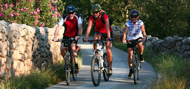
 BIKE ROADS
 A SHORT JOURNEY THROUGH HISTORY
 INSTRUCTIVE PATH MIRILA
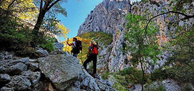
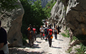 HIKING IN PAKLENICA
Route No. 1 STARIGRAD
Starigrad-Paklenica - Modrič - Starigrad-Paklenica
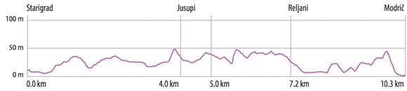
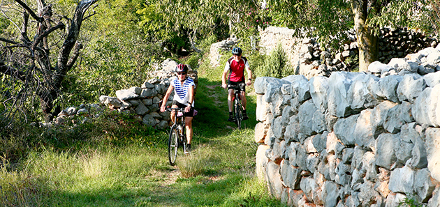
This bicycle route leads you through picturesque villages in the Velebit area, which are characterized by traditional stone architecture as well as many valuable cultural and historical sites and beautiful mountain and see landscapes. The route starts from the centre of Starigrad-Paklenica (1). You can turn left at the crossroads (2) and visit the unique headstones called MIRILA (A), made of natural stones, which can be reached after having ridden 1km uphill. The main path leads straight ahead, passing old wells and water cisterns (B), which used to be the main local water supplies. We recommend that you visit the newly-arranged ethno house (C) in the small village of Marasovići, which has a small ethnographic collection and a traditional Dalmatian wine tavern.
From this point, you can start a tour of the NP Paklenica (D) or ride down to the most beautiful beach in Starigrad, Kulina, famous for the Večka tower (E) which holds the secret of king Pasoglav… If you turn right just before the entrance of the NP Paklenica (3), the ride continues on the main path and the part of the path till the village Dadići/Škiljići is equipped with educational boards that will take you on “a short journey through the past”(F).
What follows is an easy ride passing traditional dry stone walls and old villages, with a beautiful view of the see. Just above the small village of Jurline there is another beautiful old water cistern (G) and from village of Jusupi (4), you can ride down to the centre of Seline and the local attraction - the natural pebble beach Pisak.
Riding down from the small village Reljani, you reach the main road (5). You ride along this road for 1km, after which you turn on a gravel road (6) and then reach a historical site - the ruins of Modrič fortress (H). You’ll have a magnificent view of the see and a bay, deeply cut into the mainland, interesting for its many sweat water springs which rise like pillars from the sea bed.
After descending to the centre of the village of Modrič, you take a left turn between the road and the dry stone wall (7), then cross carefully the main road and arrive at the bus station, next to which you will find a fresh water fountain named Vrilo Velebit. From this point you can continue riding on route 2 or turn back on the same path back to Starigrad-Paklenica. The unforgettable experience of the unique combination of the sea and the mountains is a whole different and more intense on the way back.
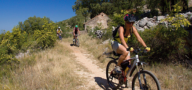
Route No. 2 MALI KAMENJAR
Modrič - Kitnasta glavica - Modrič
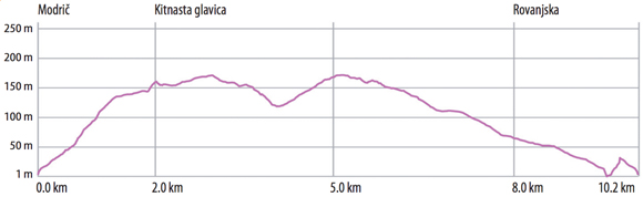
This short but attractive route leads through a characteristic rocky landscape with small plants, dominated by the silence and the view of the slopes of Velebit Mountain.
The route starts from the bus station in Modrič (1),where you can find a water spring named Vrilo Velebita next to it. The Modrič bay, deeply cut into the mainland, is famous for the sweat water springs rising like pillars from the sea bed.
After carefully crossing the main road, you ride up the Put hrvatskih brigada Street to the crossroads (2) on which you turn left and continue towards the village of Kitnasta Glavica. From the path you have a beautiful view of the sea and the mountains which give you the strength for the ride uphill. A more comfortable ride through a characteristic landscape, dominated by stone and small plants follows afterwards. You turn left at the crossroads (3) and enter the village of Kitnasta glavica. In the village (4) you have to get off your bike and push it for a while (60m), afterwards the ride continues on well arranged gravel road towards the south-east. The calming silence is occasionally interrupted by shepherds with their sheep herds on the pasture. At the crossroads (5) you cross path with route 3 which leads to the left towards the village Zelenikovac. You continue straight forward and then passing under the power-transmission lines and on the overpass above the highway, you take a right turn at the crossroads (6) and continue on the north side of the big quarry.
On the way back to Modrič you pass under the highway (7) and continue on the old main road surrounded by traditional curb stones made of natural stone. At the crossroads (8) you can turn left to the centre of Rovanjska, where it’s worth to visit the medieval church of unusual architecture, St George’s (I), located on the beach.
In the immediate vicinity of this crossroads there is the Modrič cave (J), a protected geomorphologic natural monument. The entrance of the cave is located just above the coast, with a view of the ruins of Modrič castle on the other side of the bay. The cave is arranged for organized tourist tours, which we definitely recommend you to visit while you stay in this area.
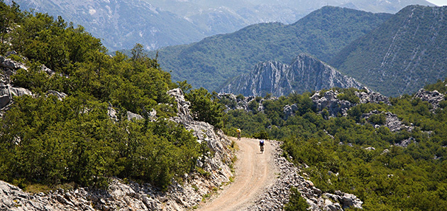
Route No. 3 VELIKI KAMENJAR
Maslenica-Zelenikovac-Jasenice-Maslenica
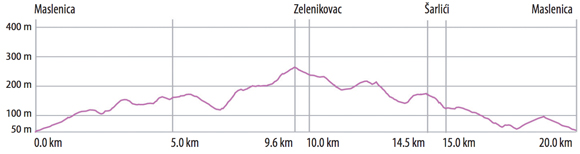
The route leads you through characteristic landscape of sea and mountains and to very attractive historical and natural locations.
The route starts from the big crossroads in Maslenica (1) where you turn on to a gravel road. After a pleasant ride through the intact nature, you turn left at the crossroads (2) and continue through the quarry in northwest direction, enjoying the view of the mountain tops of the Velebit. A double crossroads follows on the main road (3). After the second crossroads, you turn right on to a gravel road and continue to the next crossroads (4) where you once again turn right. The ride continues through a rocky landscape with small plants.
After you pass the overpass above the highway and under the powertransmission lines, you slowly ride down the hill to the crossroads (5) from where it’s possible to go forward to the village of Kitnasta Glavica or just follow the main road of this route leading towards the village of Zelenikovac. The easy uphill ride is accompanied by a calming silence and a beautiful view of the mountain tops and occasionally you can see sheep herds on the pasture.
Soon after the next right turn at the crossroads (6) you reach a big plateau beneath the village of Zelenikovac. You ride straight ahead along traditional dry stone walls, after which the road descends to the right towards the south.
The road soon turns left (7); following the highway to the underpass (8). After the underpass, the ride continues towards the south. After you reach the main road (9), you shortly ride on the right side, carefully cross the road and reach a junction leading towards the lookout point Pariževačka glavica (K), which also is where you have the best view of the canyon of river Zrmanja.
The main road leads to the right, following the road towards Jasenice. At the crossroad (10) you ride on the left on a regional road through the village of Šarlići alongside a peaceful green valley. You can turn right at the crossroads towards the village of Jasenice where we recommend you to visit the St Jeronimo’s (L) church entirely built of stone.
After leaving the village of Šarlići, the route continues in south-west direction towards the Novigrad Sea. A junction at the crossroads (11) leads you to the lookout point (N) from where you have a view of a century old olive groves, the sea and a romantic beach beneath the lookout point. The main road leads to the right, back to Maslenica to the starting point of this adventure.
Route No. 4 ZRMANJA
Golubić - Kaštel-Žegarski - Muškovci
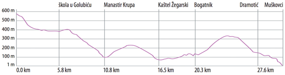
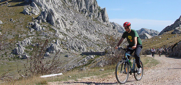
This path, which is the longest one and in its largest part covered with asphalt, runs through the fascinating landscape entangled with the playful streams, spectacular canyons, hidden wellsprings, and estuaries of Zrmanja river and its confluents.
The path runs alongside with the state road Obrovac - Gračac, on the branching-off road that is steeply and twistingly on the decline in the direction of place named Kaštel Žegarski (1) . After 4.5 km (2) it is possible to turn to the right side, on the macadam road towards the village Ravni Golubić. There is a marked hiking path running from the village up to the observation tower (A) and from that place an exceptionally beautiful view is reaching out as far as you can cast your eyes on the estuary of river Krupa into Zrmanja in front of you. After 5.8 km (3) there is also one another right branching-off road. Passing through the macadam road it leads to the place where a magnificant view is reaching out the canyon of river Krupa. By all means we recommend you also walking down the hiking path towards the bridge named Kudin most (B).
The main path continues along the road and after less than one kilometre gets to the another one observation tower. From that place you have an opportunity to see a magnificent estuary of a small river Krnjeza into the river Krupa (4). The path goes down from this place towards the convent of Krupa (C) and after that you are reaching Kaštel Žegarski. That is the starting position for rafting and kayak excursions. From Kaštel Žegarski you turn to the right side in the direction of Obrovac. During your driving you can enjoy an unforgettable view all over a deeply indented canyon of Zrmanja river and the Velebit ridges. Leaving the village named Bogatnik behind you, on the 23.9 km the path is branching away, so you can turn to the right towards the place named Bilišani. After 23.9 km the path continues, covered with asphalt in this section in the direction of Bilišani and after 1.6 km changes direction, turning to the right. Now you are on the macadam road again and driving this road along there you can arrive at the place named Muškovci.
Here you can get some rest and take refreshment, you can also go for a walk to the enchanting waterfall by name of Berberov buk (D), you have an opportunity to visit the village by name of Ogare, and freshen up yourself by having a bath in the waters of river Zrmanja that are clear as crystal. The exciting rafting adventures as well come to an end right here, because from this place forward the flow of river Zrmanja subsequently calms down. Soon afterwards the river finally merges into the sea. The path between (8) - (9) is not specifically marked and is ridden on the local street.

Cycle and footpath A SHORT JOURNEY THROUGH THE PAST
- Path length: Starigrad-Reljani 8km
- Path class: easy
This is the walking and cycling path which connects the villages Starigrad and Seline, the coast with the mountainous region, the past with present.
If you start your tour from the center of Starigrad-Paklenica, you will first have an easy walk/ride through the streets of Starigrad that can be enriched with the visit of an informative hiking hiking trail Mirila Starigrad. This will give you the opportunity to get acquainted with the unique Croatian cultural heritage – stone memorials located along the paths of Velebit, providing evidance of the former way of life and death on the slopes of Velebit.
We reccommend you to visit a small ethnographic museum and Dalmatian tavern in the ethno house in a small village Marasović. From here you can set off to the Nacional Park Paklenica or stick to the path going through picturesque old villages located on gentle slopes with wonderful views of the sea. You will also pass by the old wells and cisterns which used to be the main locaj water supplies. The last village on this path is Reljani, from where you are coming back with a same path or by the coast.
You can easily reach the coast from each village on this path and have refreshment in one of many restaurants and coffee bars or take a swimm in crystal clear sea. You will enjoy immensely the bretahtaking beauty of natural beaches Pisak and Kulina.
There is a tower called Večka kula at the final cape of the beach Kulina, which hides the secret of King Pasoglav….In the closest vicinity there is the church of St.Peter (10th Century) absolutely worth visiting.
Full of impressions and new information on traditional life and habits of the region lying at the foot of Velebit, you can come back to Starigrad-Paklenica, where this short journey through the passt has started.
Mirila
Mirila, stone monuments to the departed, can be found along the mountain paths, passes, elevations and clearings of Mt. Velebit. Mirila date from the times of the Velebit hamlets (17th–20th centuries), that mainly survived from animal husbandry.
They preserve the memories of persons who died on the mountain slopes and had to be carried to the village church and then to the cemetery where they were buried. On such arduous journeys, it was only permitted to stop, rest and place the deceased on the ground in one place - the place where the deceased would greet the sun for the last time.
On this place was erected a mirilo, the resting place of the deceased. Flat stone tablets were generally laid at the head and foot of the deceased, marking his height, to be connected at a later date by a row of stone tablets. The headstones were also sometimes subsequently adorned with symbols carved in shallow relief. These mirila were venerated and visited more than graves, as it was believed that the grave only contained “the body without the soul, which remained at the mirilo.”
Mystical artistic markings on the headstones, among which the cross and solar circle were the most common, bear witness to a continuity of artistic adornment from prehistoric cultures, via early Christianity and the iconography of the stećak (medieval Bosnian standing tombstone), while inscriptions are rare and belong to more recent times. As the stone markers of a unique funeral cult, mirila convey the customs, way of life and creativity of an entire era.
Instructive path STARIGRAD
- Time necessary for the tour: 1,30 h
- Necessary equipment: sports clothing and shoes, water;
- Difficulty of path: medium difficulty
- Length of path: 3 km
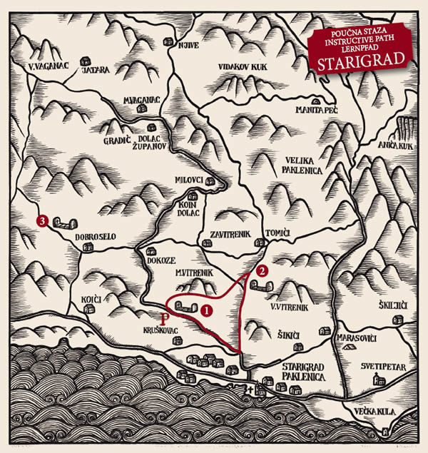
Artistic images of the Starigrad mirila (a resting spot for the body during the funeral procession from distant mountain villages to the grave - the mirila was built specifically for the deceased and once built, it was said that his mirila had been made; mirila = measure in the Dalmatian dialect), despite their rustic quality, the wealth of the raised engraving etched into the head stones is fascinating. At the first site along this trail, which can be reached from the road from the centre of Starigrad, is one of the rarely preserved headstones with an engraved anthropomorphic (human-like) symbol.
From here, the mountain trail leads to the site Opuvani dolac, offer a magnificent view over Starigrad along the route. It is the iconography of the mirila that makes them so distinctive, and here, it is possible to see many different symbols - from the simple motif of the cross (Latin, Greek, solar, anthropomorphic), often in combination with solar circles, to fully undefined symbols (rosettes, spirals, four-hooks), whose meaning is known only to the master who engraved them...
The return trip to Starigrad leads along a skilfully built trail down the steep slopes of Veliki Vitrenik. At the end of the trail, we recommend a visit to the small ethnography museum in the village of Marasovići to become better acquainted with the traditions, customs and culture of the Velebit region.
Instructive path LJUBOTIĆ
- Time necessary for the tour: 2 h
- Necessary equipment: sports clothing and shoes, water;
- Difficulty of path: easy, with the exception of the ascent to Locality 5 and the descent to the village Ljubotić - medium difficulty
- Length of path: 5 km
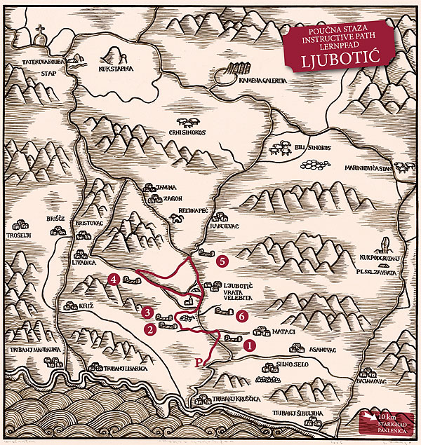
The path includes 6 localities with mirila in the immediate vicinity of the village of Ljubotić, the former hub of this part of Velebit, to which the population of all the surrounding hamlets gravitated. This is also the location of the local cemetery - the starting place for the processions that carried the deceased to burial. Each of these localities contributes to a part of the story of this unique custom through words and pictures. The largest preserved group of over 300 mirila is the so-called Vukićeva mirila (6), located along an old path that connected the hamlet of Bristovac with Ljubotić.
From the elevation on which the so-called Renjevačka mirila are located (5), there is a beautiful view of the entire Velebit Channel, all the way to the Zadar Archipelago.
On the return trip, there is an opportunity to rest at the village household of Vrata Velebita, visit an ethno-house and a permanent exhibit on the development of beekeeping in Dalmatia and the Mediterranean. With advance notice, it is also possible to savor domestic specialties.
HIKING IN PAKLENICA
Hiking is the only way to really get to know Paklenica. The Park area contains more then 150km of trails and paths, from those prepared for tourists, leading through the canyons Velika and Mala Paklenica, to those prepared for mountaineers, leading to the highest peaks of Velebit, Vaganski vrh(1.757m) and the Sveto brdo(1.753m).
Here we will introduce you to a few the most visited trails. For mountaineering trails we reccommend you to use specialized mountaineering maps availible at the Park entrance and at the souvenir shops. There are also half-day and wholeday guided tours through the Park.
The most popular trails in Paklenica National Park
Velika Paklenica – Anića luka - Lugarnica – Paklenica Mountain Hut
- route difficulty 1.5/5
- walking time 2 hours
- vertical drop 400 m
- features on thje trail Paklenica mills, Velika Paklenica Canyon, karstic phenomena, stream falls, climbing area, Anića kuk rock, Lugarnica forest cottage, hut in Paklenica at the foot of mountain villages of Parići and Ramići.
Velika Paklenica – Anića luka - Manita peć
- route difficulty 2/5
- walking time 1,5 hours
- vertical drop 450 m
- features on the trail a panoramic view of the cliffs of Anića kuk, Jurasova glavica and Manita peć (Zub od Manite peći), Manita peć cave
Velika Paklenica – Paklenica mill – Paklarić Fort
- route difficulty 1.5/5
- walking time 1 hour
- vertical drop 120 m
- features on the trail the old mill, the viewpoint with panoramic view to the sea and the mountains, educational boards, karstic phenomena, Paklarić Fort.
Reception - V. Paklenica – Anića luka – Grabove doline – Njive lekine – Mala Paklenica – Seline
- route difficulty 4/5
- walking time 6 hours
- vertical drop 650 m
- features on the trail Velika Paklenica Canyon, black pine and beech woods, Vodarica pit, Kapljarka cave, karstic phenomena, Mala Paklenica Canyon.
More about hiking and mountaineering in Paklenica: Nacionalni park Paklenica.